When William the Conqueror invaded England in 1066, the town of Hastings was almost certainly on a headland now known as White Rock. At that time, White Rock was a promontory stretching perhaps up to 200 yards further into the English Channel than it does now, with much of the first town of Hastings probably sited on the section of it that has been lost to the sea.
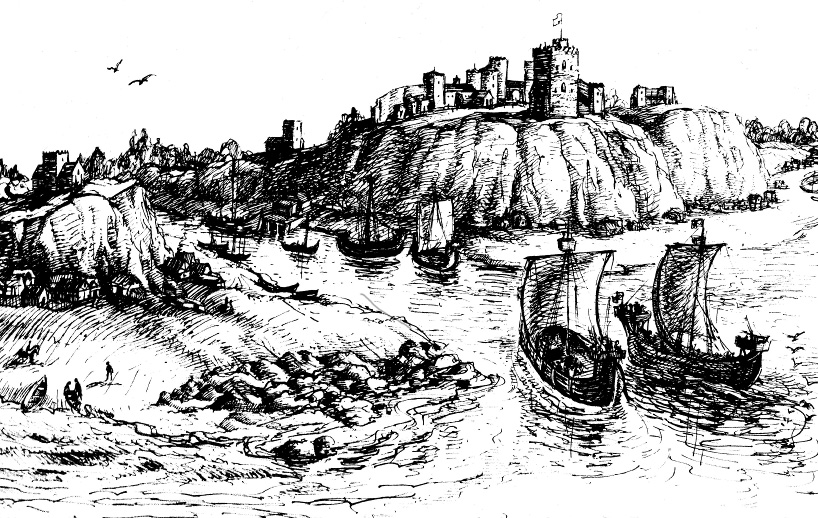 Hastings in 1066 as it might have been
After the last Ice Age ended about 8000 BC, sea levels rose following the melting of the ice covering much of northern Europe, and by around 3000 BC the British Isles had roughly taken the shape we know today. The eastern Sussex coast was a succession of promontories and inlets, with low-lying land in front of it, going out probably several hundred yards (or more) to where the sea then was. In the Hastings and St Leonards area, all today’s high ground went further to seaward, but probably sloping down from the height which the land now has. The evidence of this is the large number of trees dating from around 1500 BC to 2000 BC which can be seen at low tides on much of the seabed between Pett Level and Bexhill, showing that this was low-lying dry land at that time. At White Rock many large old oak trees were found while the foundations of the seaward end of Hastings Pier were being laid in 1870-71.
Since around 1000 BC, when the sea level stopped rising through the melting of ice, the many changes in the coastline have been the result of shingle movement and steady erosion.
The town of Hastings came into existence in the 9th century, but it was not in the Bourne Valley, where the Old Town is today. The Bourne Valley was narrower and shallower than the Priory Valley, now home to the town centre, which in Saxon times was a wide estuary forming a natural harbour, with sheltered waters in the lee of White Rock.
The main method of transport and communication at that time was by water when possible, using natural havens and estuaries like the Priory as harbours. The Priory estuary was also one of the nearest ports of passage to and from the continent for the important cross-Channel trade, and this would probably have been a major reason for the gradual creation of the town of Hastings in the early 9th century, and for it being located on the White Rock headland and its slopes. In addition, King Alfred in the late 9th century made Hastings a ‘burh’, a fortified settlement defending both the port and eastern Sussex from attacks by the Vikings. It housed a mint. Plus Hastings has always been a significant fishing port since records began.
At the time of the Battle of Hastings in 1066, the headland of White Rock protruded from the land between what are now Prospect Place and the top of White Rock Road where it starts dipping south-westwards towards the seafront. With all land in the Hastings area going further to seaward than today, there were then several parish churches along the coast between the East Hill and Bopeep. The church on top of White Rock was dedicated to St Michael, the leader of the ‘Army of God’, and as St Michael was depicted on the town’s medieval seal, it is seems that this church was the most important in the borough.
St Michael’s Church stood on the eastern end of the headland, and most, if not all of it had been washed away by the early 15th century, and possibly before then. When the headland was cut back in the early 1830s, graves and human bones were found on the cliff edge. The church was in the ancient parish of St Michael, only a small section of which survives today, lying between Prospect Place and the east side of Dorset Place, and going as far north as Cambridge Road.
There are no known archaeological remains of the Saxon town of Hastings on White Rock, probably because of the loss of all or most of the site as a result of coastal erosion until the early 19th century, and building work since then. It is also likely that William the Conqueror burnt at least some of the town in 1066, although in the following decades Hastings still had a large fleet of deep-water fishing boats, showing that the borough had survived the invasion, and that it remained an active port. From the late 11th century onwards Hastings seems to have expanded into the Bourne Valley, although the Priory Valley and White Rock appear to have remained the focus of the town.1
By the 13th century the Bourne Valley suburb had grown to a considerable size, with two churches: All Saints and St Clements. This 'new town' was originally situated mostly to seaward of today’s streets and buildings, but severe storms in the mid- and late-13th century destroyed much of it, resulting in the setting up of what is now called the Old Town further up the valley, as it is today. These storms also probably severely damaged the original town of Hastings, and eroded White Rock and other parts of the coast.
From then onwards the town of Hastings was in the Bourne Valley, and the White Rock headland seems to have been used mainly as farmland. But it was also still enough of a promontory to continue providing shelter to the beach and the Priory Valley immediately to the east of it, and it was on this ground that the Rock Fair was held every year on July 26 and 27. This was the biggest of the town’s three annual fairs, and it had probably been arranged from time immemorial at or near this spot - the triangle of Robertson Street, Claremont and Trinity Street - and it presumably took its name from the adjoining White Rock.
The name ‘White Rock’ almost certainly came from the colour of its cliffs and rocks, a yellow-brown sandstone which could be bleached to near-white when washed by the sea.
The earliest local maps, dating from the first half of the 18th century, show a headland extending out from around the area where White Rock Gardens are today. A small-scale map by Budgen in 1724 has rocks in front of the headland, with ‘White Rocks’ printed alongside. A larger scale map by Samuel Cant in 1746 has ‘White Rock’ beside the headland, which, if the map is accurate, seems to have survived coastal erosion better than the part of the promontory to the east of it.
The 1746 map also shows that the area around today’s St Michael’s Place, on the east side of Dorset Place, was a tall knoll, with a windmill on it. From the early 18th century (or earlier) until late Victorian times this windmill hill was called ‘Cuckoo Hill’. Town records of 1832 describe Dorset Place as the road ‘up Mill Hollow to the White Rock’. The first large-scale Ordnance Survey map of Hastings, surveyed in 1873, calls the whole White Rock area ‘Cuckoo Hill’, while next to the rocks in the sea in front of the hill it says ‘St Michael on the Rock’. Before the 18th century the headland seems to have been known as ‘St Michael’s Hill’, with ‘St Michael’s Cliff’ in front of it.
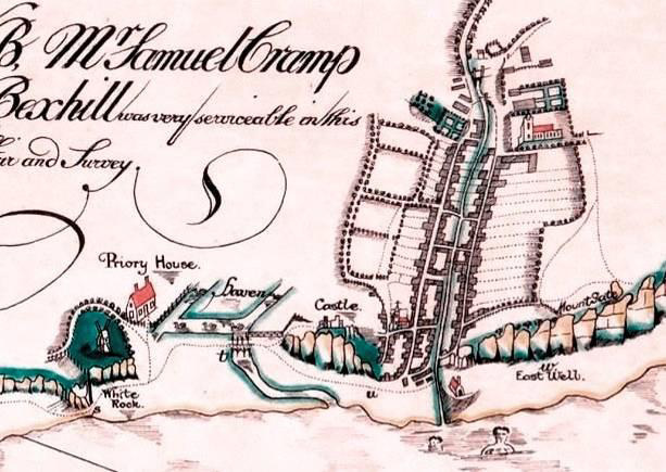 Hastings in 1746
In the late 18th century Hastings started becoming a popular seaside resort, and the grassy high area of Cuckoo Hill became a promenade and viewpoint for the town’s visitors. But the town became especially fashionable from about 1814 onwards, and this meant that geographical communications had to be significantly improved, with roads becoming much more important.
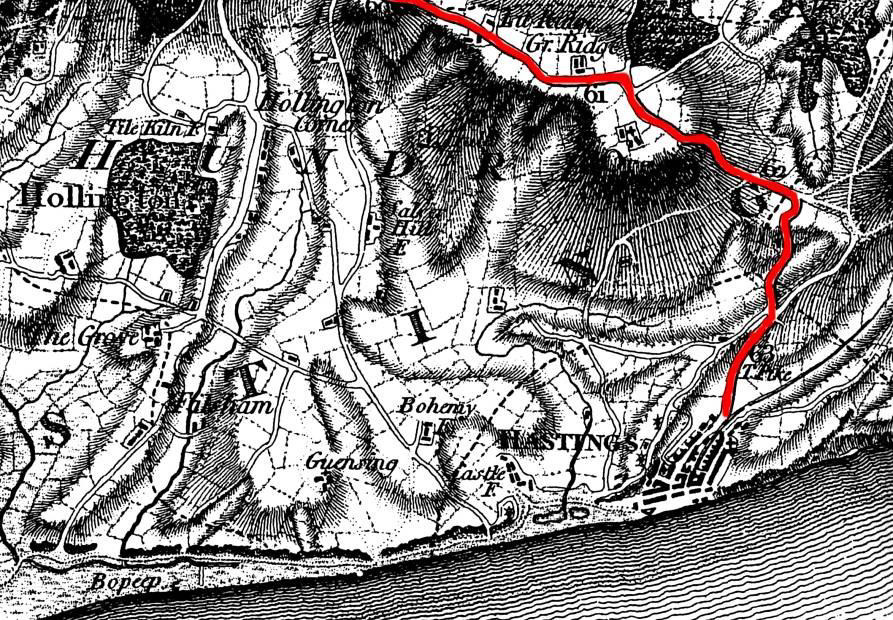
Until the early 1830s the main road out of Hastings (in red below) was Old London Road out of the Old Town, which became a turnpike road at Mount Road, and then went north-west along the Ridge, via Battle, to London. The other road heading inland from Hastings was via the steep and unmade-up Dorset Place on White Rock, which went round the inland side of Cuckoo Hill, and then went via the rough tracks of White Rock Road, Bohemia Road and Hollington Old Lane to join the turnpike road at Beauport, on the Ridge. Cambridge Road and Battle Road as we know them today were created as a new turnpike road in 1836-38.
 1795
1795
Before 1835, travellers heading west from Hastings along the coast towards Lewes had to follow a track along the bottom of St Michael’s Cliff and the cliffs of St Leonards. The first 350 yards of this track started at the end of today’s Robertson Street and gradually rose up the remains of the headland (in front of what is now White Rock Gardens) where a mass of huge boulders, perhaps 40 feet high, reached from the foot of the cliff into the sea at high tide. From there the track sloped down to where Verulam Place is now.
To get past this pile of boulders, a partially-sunken roadway had been cut through them, possibly in the late 18th century. The road closely skirted the base of the cliff and gradually went up to a height of about 25 feet above sea level in the cutting. This roadway was a key part of the coastal route going west, but in gales and very high tides it was dangerous to use or was even unusable, and the only alternative was to struggle up the steep track of what is now Dorset Place onto the 90 feet high White Rock and then go down a similar track on the other side, rejoining the coastal route at today’s Verulam Place.
The creation by James Burton of the new town of St Leonards from 1828 added significantly to the serious problems of this coast road, while at the same time greatly emphasising the need to improve it.
St Leonards was designed specifically for the higher class of people living in London who sought a seaside holiday resort, and had few shops or working class residents. The new town therefore relied on lower class Hastings to supply it with many goods and services, and this involved the use of lots of vehicles, whose horses and wheels made both of the existing low-quality roadways even worse than they were already. In addition, in the early 1830s the sea-walls, roads and parades built in front of the new St Leonards had the effect of forcing the sea more than ever on to all of the coast road to the east, and it also undermined White Rock headland.
However, prominent local businessmen saw that the two towns would probably merge, especially if there were a proper link road under the cliffs. By early 1834 the speculators had already started investing in the future by beginning to cut back St Michael’s Cliff, from Robertson Street towards the western end of the shops in White Rock today. At this time the track under the cliff, sometimes known as the High Road, was officially named as Stratford Place, but all the seafront between the Robertson Street and the pier was also often called White Rock Place, until being formally renamed as White Rock in 1881.The high cliff-face was stabilised with large-scale brickwork from the early 1830s, and businesses were being built when possible. These included two big enterprises: Rock’s Coach Factory (later Courts the Furnishers), built in 1834/5, and the White Rock Brewery. Also at this time, part of the cliff was cut back at Verulam Place, immediately to the west of today’s pier, and ten houses were built there in 1833 or soon after.
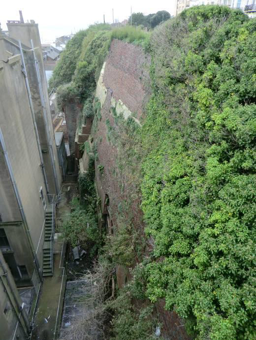 The bricked cliffs behind Palace Chambers
By mid-1834 the speculators had made plans on how to complete the cutting back of all the cliff from Stratford Place to the new town of St Leonards, to both make a decent road and to build housing and businesses on all the newly-created ground. This would involve demolition of the remains of the headland. But there were several gales that year, culminating in a severe storm on 18/19 October 1834 which caused much damage along the coast, and partially undermined the new businesses at Stratford Place. This generated great fears for their safety, and temporary sea defences were put up in front of them.
Then just a fortnight later, on 4 November 1834, the heiress-apparent to the throne of England, 15-year old Princess Victoria, came to stay in St Leonards. She travelled from London by road, passing through Hastings en route. But the White Rock coast road had been made impassable by the recent storm, so the entourage had to take the very difficult route via Dorset Place, which had also been damaged by increased use following the breaking up the coast road by the gales.
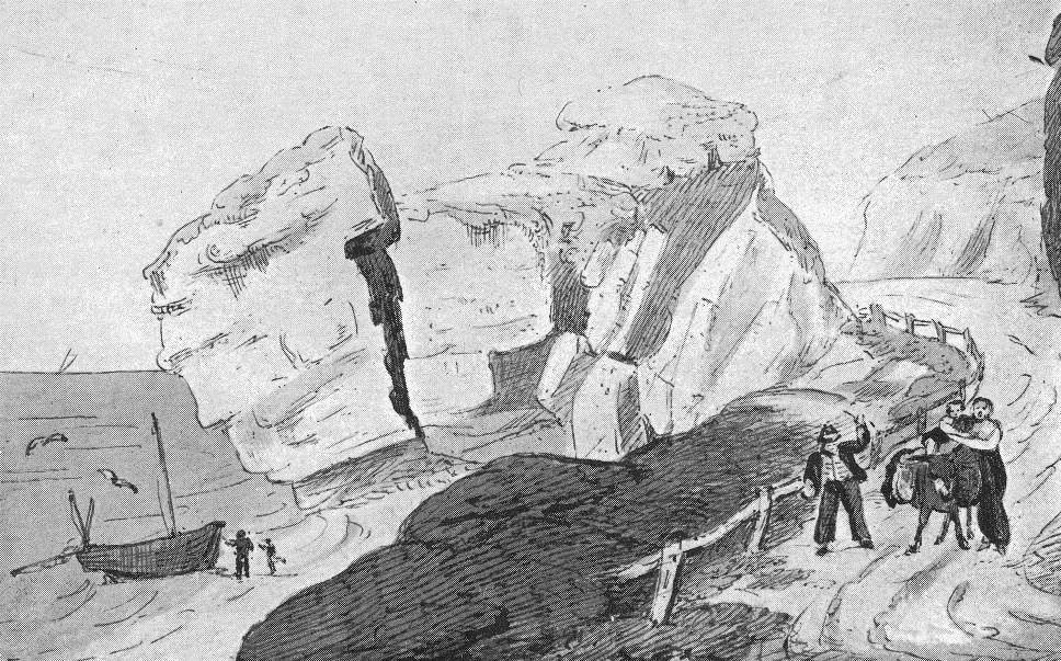 White Rock headland in the early 1800s
The hard time for the royal tour, plus the possible loss of future income through the near-destruction of the coast road, prompted the local establishment to immediately complete the much-needed proper highway between the two towns. But there was a nearly mile-long gap between the official eastern boundary of St Leonards and the western boundary of Hastings, so neither local authority could pay for the project.
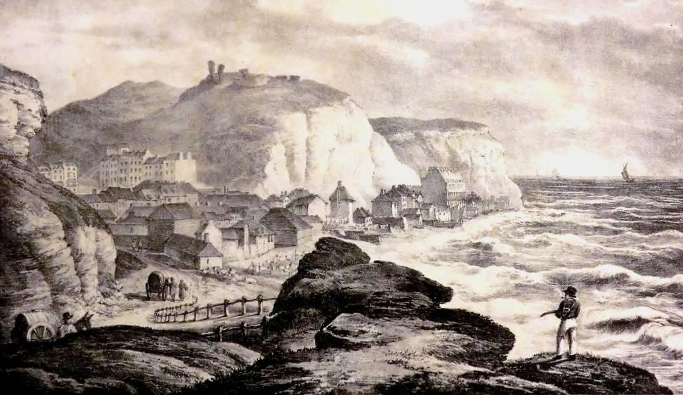 The view of the town from the headland in 1824
The speculators therefore set up a fund to pay for the scheme. Its main investor was Charles Eversfield, whose Eversfield Estate owned much of the St Leonards cliffs, and who hoped to realise a large return from this gamble. The project removed the White Rock headland by blowing it up with gunpowder in the winter of 1834/5, and all the indented cliffs to the west were cut back. The excavated rocks were used to heighten the ground level in front of the cliffs, creating a raised and protected road and parade, running from today’s Robertson Street to London Road.
This major work, completed by late 1835, coincided with the erection of a new coastguard station on top of the cliff in what is now called St Michael’s Place. The construction of the station, which is little-changed today and is the oldest surviving coastguard building in the Hastings area, included the creation from the bottom of Dorset Place of Prospect Place, the original name of St Michael’s Place.
At the same time, the cliff behind the White Rock Brewery was being cut back, and the two events disturbed the St Michaels Church cemetery, in front of where St Michael’s Place is today. Human bones were found on top of the cliff, plus several graves which had been cut into solid rock, containing no indication of there having been any coffins. At the same time bones fell down the cliff and were found behind the brewery. When the brewery and the adjoining Seaside Hotel were replaced by the 125 feet long and 80 feet deep 140-rooms Palace Hotel in 1885 more human bones were found when laying the new foundations.
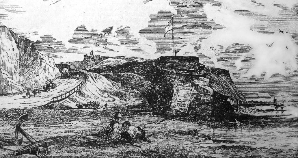 The headland before demolition looking up White Rock Road
In the 1820s and ‘30s local historian Thomas Brett (1816-1906) knew the White Rock area well. He recalled that in the 1820s the headland was very uneven. Cuckoo Hill (also called Cuckoo Hill Field) was especially conspicuous, but it was lowered in height and levelled to create the site of the coastguard station. Brett also saw what he thought may have been part of St Michael’s Church, saying: “I had been an occasional laundry boy, and had dried clothes on Cuckoo-hill, and had fixed my line to a staple driven into a piece of old masonry that was understood to be the ruins of St Michael’s-on-the-Rock.”2 He said the hill “was sometimes called St Michael’s Rock.”3
Brett described the headland of “White Rock Hill” as a “steep and rugged projection” to the west of Cuckoo Hill.4 At the top of White Rock Hill was a cottage known as Shepherds House, with a slaughter-house in its basement. During the Napoleonic wars a flagstaff for signalling was placed on the sea end of the promontory, plus three cannon taken from a captured French warship. After descending the steep track from the top of White Rock Hill to Verulam Place, the coast road to St Leonards until 1835 was made of loose beach and faggots in many parts.
By 1836 not only had the coastal track west of Robertson Street been made into a proper highway and promenade, but work had started on ending Dorset Place’s role as the alternative to Old London Road as a northbound road out of Hastings.
Until then the road that is now Claremont did not have a flight of steps up into Cambridge Road as it does today, but instead carried on at roughly the same level inland to Priory Farm, where Cambridge Gardens is now. By the mid-1830s, however, the increasing size of the town in all directions highlighted the need for both more and better roads, and so several turnpike roads were built. These included constructing today’s gently-sloping Cambridge Road in 1836-38, which by-passed Dorset Place.
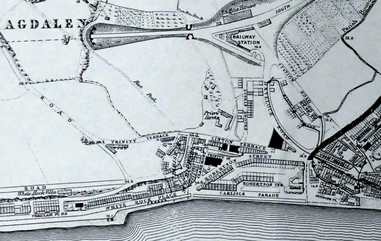 Hastings in 1859
The new Cambridge Road was formed by cutting through the hill from the bottom of Dorset Place up to the open ground at the Oval, and laying the spoil at the town centre end of these roadworks, thus blocking the end of Claremont. Similar cutting, levelling and straightening took place all along Bohemia Road to Silverhill. Here the new Battle Road cut through the hill to the north, and a large straight embankment was laid right across the valley through Hollington village eventually connecting at Beauport with the existing turnpike road, the Ridge.
So by the end of the 1830s the top of White Rock had stopped being a through-route for traffic, while the road along its seafront was to become part of the A259, the main coast road.
 1956
1956
By the early 1850s nearly all this new land at the bottom of the cliffs between White Rock and St Leonards had been developed, thereby forging a physical link between Hastings and St Leonards. Also by then, the original Norman Road in St Leonards had been laid along the top of the cliffs from London Road to Dorset Place, parallel to the coast road. Its eastern end went undeveloped, but survives today as both St Margaret’s Road and the large pathway connecting the bottom of Falaise Road and White Rock Gardens.
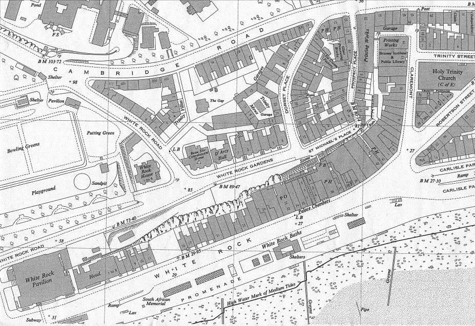
In December 1839 work began on laying the foundations of the Hastings Infirmary, where the White Rock Theatre is today. It opened in June 1842 and was initially a hospital for the better-off people of Hastings. At that time the road behind the infirmary (now called White Rock Road) was closer to the sea than it is today, and it can still be seen, covered in grass and bushes, running alongside the pavement.
The infirmary was replaced on the same site in 1887 by the much larger general-purpose East Sussex Hospital. In late 1913 Hastings Council began a series of improvements to the White Rock area that included pushing White Rock Road back to its present location. The hospital was relocated to Bohemia Road as the Royal East Sussex Hospital in 1923, and Hastings Council then demolished the old building and replaced it with the White Rock Pavilion, which opened in 1927.
Two other major changes in the history of the White Rock area were the building of Hastings Pier from 1869-72, and the construction of the White Rock Baths. The first part of the baths opened in May 1878. This was a 180' x 40' men’s pool, said to be the largest swimming pool in the world. The women’s pool opened in July 1879, private baths and other facilities in August 1880, and the Turkish Baths in April 1882.
Nowadays, with the probable site of the first town of Hastings having been largely lost to the sea, the former significance of White Rock has been mostly forgotten, but it should always be remembered as being originally an important part of the history of Hastings and St Leonards.
Notes
1 HAARG Journal December 1999 p 2
2 TB Brett, History of Hastings & St Leonards vol one p 87
3 Brett vol two p 131
4 Brett vol one p 37
© Steve Peak 2015